

Quick answer
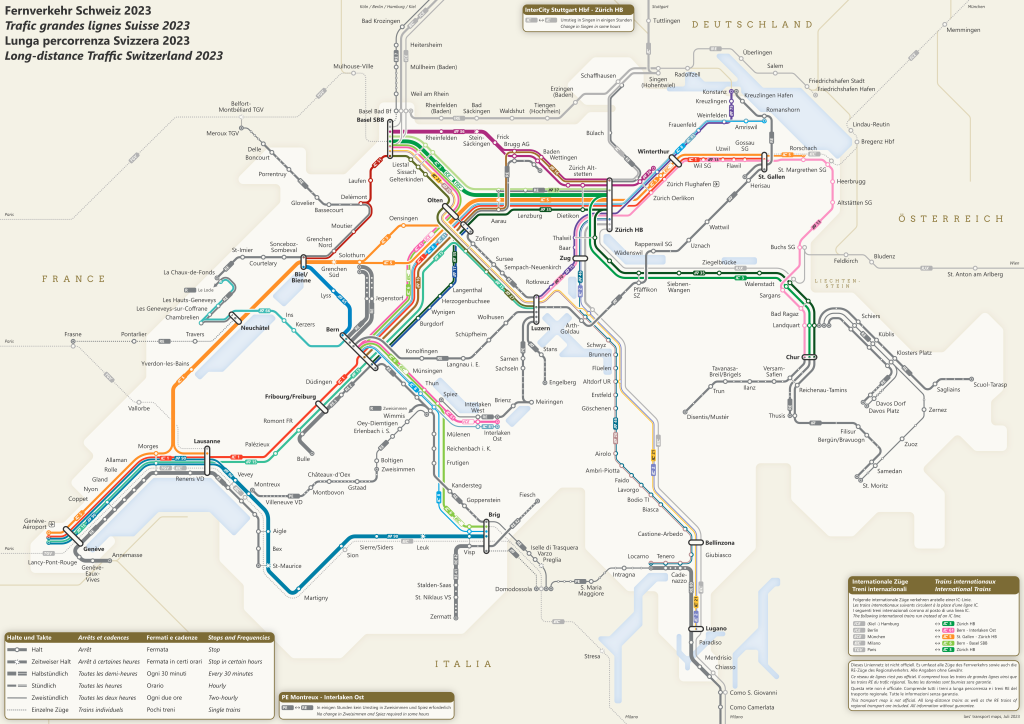
The swiss train travel map is available free through the SBB website and mobile app, showing the complete network of intercity, regional, and narrow-gauge lines across Switzerland. The interactive version allows you to filter by train type, search stations by name or zone, and overlay real-time service updates. Paper versions are distributed at SBB ticket counters and information desks in major stations.
Switzerland operates one of the world's densest rail networks, with trains departing every few minutes during peak hours and reaching elevations above 3,400 meters. The topology—mountain passes, lake routes, and cross-border links—creates routing complexity that a good swiss train travel map resolves at a glance. Passengers planning multi-day itineraries or connecting between narrow-gauge heritage lines and standard intercity services rely on these maps to spot transfer hubs and avoid backtracking. The official SBB network diagram uses a schematic layout rather than geographic accuracy, prioritizing legibility over scale. Intercity lines appear as bold strokes, regional services as thinner branches, and funicular or rack-railway connections as dotted segments. Each line carries a letter-number designation—IR 15, S3, RE 450—that corresponds to timetable entries and platform signage. Stations with international connections are marked with country flags; those offering bicycle rental or left-luggage facilities carry service icons in the margin. The map updates quarterly to reflect seasonal route suspensions, construction diversions, and new rolling stock deployments. Route planning starts with identifying your origin and destination stations, then tracing the fewest transfers. High-traffic corridors like Zurich–Bern or Geneva–Lausanne offer direct intercity service every thirty minutes, while alpine branches require a change at valley nodes such as Interlaken Ost or Chur. The SBB journey planner cross-references the network map with live departure boards, suggesting alternative routings when delays cascade through connecting services. Travelers can download regional map sections as PDFs for offline reference or request a full-color poster version by mail. Most passengers consult the railway network overview before purchasing multi-day passes, as coverage boundaries determine whether a ticket includes mountain railways, lake steamers, or postal bus feeders. The Swiss Travel Pass, for example, grants unlimited access to the entire SBB network plus private operators within the validity zone, but certain high-alpine routes levy a supplementary fare. Comparing the pass coverage map against your planned itinerary prevents surprises at turnstiles and ensures you board the correct service class.
“The schematic layout prioritizes transfer clarity over geographic scale, rendering a 200-kilometer journey and a 15-kilometer spur with equal visual weight.”
SBB Customer Support Hours for Swiss Train Travel Map Assistance
The Swiss Federal Railways (SBB) network map information is available online at all times. Travelers can access digital resources and route visualization tools continuously throughout the week.
| Monday | 00:00–23:59 | |
|---|---|---|
| Tuesday | 00:00–23:59 | |
| Wednesday | 00:00–23:59 | |
| Thursday | 00:00–23:59 | |
| Friday | 00:00–23:59 | |
| Saturday | 00:00–23:59 | |
| Sunday | 00:00–23:59 |
Reaching Swiss Federal Railways (SBB) for Swiss Train Travel Map Support
The Swiss Federal Railways (SBB) headquarters is located at Mittelstrasse 43 in Bern. Visitors requiring in-person support can reach this location via the Bern central rail hub.
InterCity or Regional train to Bern Bahnhof
Bern Bahnhof to Mittelstrasse 43
Bern Bahnhof to Mittelstrasse 43
Pro Tips for Navigating Your Swiss Train Travel Map
Master the Swiss rail network with these strategic approaches to route planning and real-time navigation.
Download offline maps
Save the official SBB network map as a PDF to your mobile device to ensure navigation capabilities remain functional in areas with limited cellular coverage.
Identify panoramic routes
Look for the specialized icons on the interactive map that designate panoramic lines, which often require specific seat reservations despite being part of the standard network.
Use real-time status updates
Check the SBB mobile application concurrently with your static map to identify track changes, construction delays, or service disruptions in real time.
Prioritize regional connections
Zoom into specific regions on the digital map to identify local lines that connect smaller villages often omitted from the main overview map.
Coordinate with platform indicators
When viewing a route on your map, cross-reference the platform numbers displayed at the station, as these are synchronized directly with the live network data.
Check availability
Frequently asked questions about swiss train travel map
Everything you need to know about swiss train travel map